St. Nikolaus, Mariahilf, Hötting and Mühlau
Things to know about St Nicholas & Mariahilf
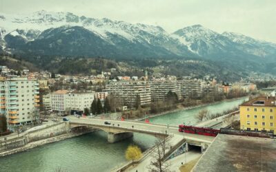
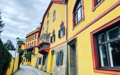
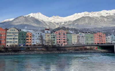
Wenn man so will, nahm Innsbruck im 12. Jahrhundert seinen Anfang bei den bunten Häusern am nördlichen Innufer. 1133 tauchte ein Markt namens Innspruke or Ynbruggen erstmals in Urkunden auf. Die Siedlung entstand entlang des Verkehrsweges bei der Innbrücke. Als die Stadt über den Fluss expandierte, etablierte sich für die alten Teile am Nordufer der Name Anpruggen. Der heutige Stadtteil Mariahilf westlich der Innbrücke war bis zur Fertigstellung der Pfarrkirche im 17. Jahrhundert als Obere Anpruggen bekannt, die heutige Mariahilfstraße trug bis 1837 den Namen Obere Innbrückenstraße. Von der Stadt durch den Fluss getrennt, entwickelte sich am Südufer ein eigener Mikrokosmos, der sich sowohl vom Nordufer wie auch vom darüberliegenden Hötting unterschied. Anders als in der von Händlern, Beamten, Bankiers und Angehörigen des Hofstaats geprägten Stadt oder den bäuerlichen Dörfern der Umgebung siedelten sich in Anpruggen Fuhrwerker, Flößer, Arbeiter, Wagner, Schmiede und Gastwirte an, um den Durchzugsverkehr zu servicieren und finanziell zu nutzen. Im Westen ging Anpruggen in die Höttinger Au über, ein Schwemmgebiet, das von den Bauern als Allmende genutzt wurde. Wo heute die Türme des Mariahilfparks in den Himmel ragen, entstanden im Wachstum des 19. Jahrhunderts die typischen Mietzinshäuser für Angestellte und Arbeiter. Anders als in Wilten und im Saggen mussten die meisten davon in den 1970er Jahren dem modernen Wohnbau Platz machen. Abseits der bunten Häuser der Mariahilfzeile und der Pfarrkirche dominieren große Wohnanlagen den relativ jungen Stadtteil.
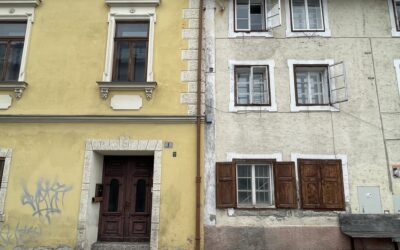
The settlement east of the Inn Bridge—today’s St. Nikolaus—was called Lower Anpruggen. St.-Nikolaus-Gasse was the main traffic route from the east to the Inn Bridge. St. Nikolaus became home to everything the city itself did not want within its walls but still needed to function: a place of execution (nicknamed Köpfplatz), a poorhouse, and later a prison. Where visitors now walk toward the Alpine Zoo, there used to be the Jewish cemetery. Innsbruck not only moved its institutional burdens to St. Nikolaus but also its everyday urban waste. Butchers working at the “Fleischbank” near the bridge threw leftovers into the river, which carried them eastward. Combined with the contents of Innsbruck’s chamber pots, high water created an especially unpleasant mix—giving local residents the long‑lasting nickname Koatlackler (roughly “manure splashers”). In the 19th century, industrial businesses and apartment buildings arrived, along with modernization. In the 1870s, the last raft landing place in St. Nikolaus was removed and the Waltherpark, a small inner-city green space, was created. East of the park, the Kreuzersteg bridge was opened in 1875. Today, the small steel truss bridge decorated with love locks is a popular photo spot thanks to the backdrop of the Nordkette mountains and the church tower. After the raft connection across the Inn ended, the bridge became an important link for pedestrians and cyclists between the north and south banks. Despite this new connection to the city and an increase in middle‑class residents, St. Nikolaus kept its own charm. Today, it is a relaxed neighborhood with many cafés, bars, and small shops.
Things to know about Hötting
The big brother of the Koatlackn, one level higher, was for a long time not part of Innsbruck. Until its incorporation in 1938, Hötting was an independent village. The boundary stone from the 18th century opposite Riedgasse 49 remains in its original place as a protected monument. With 8,000 inhabitants, Hötting was one of the largest municipalities in Tyrol in the 20th century. The Allerheiligenhöfe and the execution site Galgenbühel marked the western end of the community. Mining and large farms were the foundations of the self‑confidence with which the people of Hötting faced the city of Innsbruck. Economically, the village was long on equal footing with the city. As early as the early 16th century, Hötting had a bathhouse. Only with the development of the new district Saggen and the incorporation of Pradl and Wilten did Innsbruck finally overtake its often loud neighbor above. The people of Hötting had a reputation for being wild fellows. Hötting children were considered bad influence for the children of Innsbruck. In 1923, the newspaper reported:
"Recently, two pistols were taken from a 14-year-old boy in Schneeburggasse, with which he had allegedly amused himself by shooting sparrows. Shortly before, the dog of the tradesman Inwinkel had been shot in the square. The bullet penetrated the animal's head. As many children were playing in the square, it was fortunate that the shooting did not cause any major damage. The case is likely to have legal repercussions."
Unlike the city, with its employees in trade and administration, university professors, doctors, and lawyers, Hötting had always been home to craftsmen, gunsmiths, farmers, and workers from the mine beneath the Hungerburg or from the Rauchmühle. In the politically radical and heated atmosphere of the interwar period, the village above Innsbruck was known as "Red Hötting." The Höttinger Saalschlacht of 1932, legendary in Innsbruck, also contributed to the district’s reputation as rough terrain. Hötting has preserved a certain uniqueness to this day, even though the once rugged village is now among the most expensive residential areas of the city.
Things to know about Mühlau
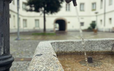
The district of Mühlau, which borders Innsbruck to the east, was an independent municipality until 1938 and was known for its historically developed industry. The name and meaning of the settlement derive from the mills that had been established along the Mühlbach as early as the Middle Ages. This watercourse, which supplied energy, also enabled Mühlau to experience its first phase of industrial prosperity. The first Sagmeister (master sawyer) was documented in 1312. A metal foundry and a tin‑plate works settled here in the 15th century. For a short time, even the sovereign mint was located in Mühlau. In the Grabenstein manor, the official currency made of Schwaz silver was produced between 1567 and 1571 using a modern roller coining machine. During the second wave of industrialisation in the 19th century, the Mühlbach became home to the Rauchmühle with its power station, a sugar factory, a paper factory, and several textile factories that shaped the character of the community. In Mühlau’s village square, the village fountain with its mill wheel and an impressive relief by Johannes Obleitner commemorate the close connection between rural and industrial life. At Holzgasse 10, the old power station of the former municipality can still be admired. For some time, Mühlau was also home to a spa facility. Only a few metres from the textile factory stood the Badehaus Mühlau, an early wellness hotel. Innsbruck had long been associated with therapeutic bathing thanks to its many springs. The city's oldest bathhouse was the Ofenlochbad in the Old Town, where since the 13th century residents had received treatments for various ailments. In the 18th century, a bathhouse for wounded soldiers existed at the military hospital beside the Mariahilf Church, supplied with water from the Höttinger Kirschental. The Neckelbrünnl was Mühlau’s own spring, long believed to possess healing properties. In 1786, the physician Martinus Scherer opened his bathhouse, offering what at the time were remarkably modern methods—steam baths, cold‑water baths, as well as iron, sulphur, and herbal baths. These treatments were intended to cure ailments such as deafness, paralysis, loss of speech, and smallpox. In the 19th century, spa tourism blossomed. The surrounding villages benefited from an increasingly affluent class of visitors burdened by the strains of modern life and longing for both Alpine idyll and modern treatments. Innsbruck was now well connected by rail and easily accessible. Mühlau, similar to Mentlberg—where a comparable establishment opened in 1884—proved ideal for spa guests. Its proximity to the city allowed visitors not exclusively focused on recovery to enjoy a degree of urban entertainment between treatments, unlike in remote mountain villages such as Davos. As the magazine Der Alpenfreund wrote in 1870:
“If, however, the mountain enthusiast is blessed with a family, neither concern for the possible nervous ailments of his dear wife nor the scrofulous conditions of one of the children should deter him from breathing out all the worries, troubles, and burdens of business life on the nearby mountains. He should simply take his loved ones with him to Mühlau, confidently leave the curing process to the care of the proprietor of the mentioned establishment, Dr. Schlechter—who knows well how to achieve his healing goals with cold‑water therapy, brine baths, gymnastics, and electro‑magnetism—and himself wander peacefully heavenward into the mountains.”
The Badehaus Mühlau at Anton‑Rauch‑Straße 30 survives today as an architecturally charming residential building preserved in 19th‑century style. The 20th century brought significant change to the village—not only the loss of independence, but also the gradual decline of tourism and industry. The western part of Mühlau, along Holzgasse and Richardsweg, remains home to some of Innsbruck’s most beautiful farmhouses and villas. High above the city, minor nobles once built a series of Ansitze, which were later eagerly taken over by the upper middle class. Perhaps the finest example is the Ansitz Sonnenheim, renovated in 1904. This striking villa in Tyrolean Heimatstil still resembles a castle today thanks to its tower. The façades feature paintings by the well‑known Pradl artist Raphael Thaler. Today, Mühlau is neither an industrial site nor a tourism hotspot. Instead, its sunny location on the edge of the city has made it a quiet yet highly sought‑after residential area. Those who can afford it still choose to live where affluent travellers already spent their holidays centuries ago.
Mariahilfpark
Mariahilfpark 1 – 4
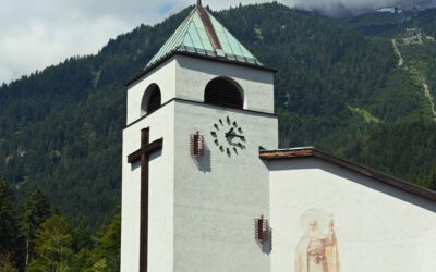
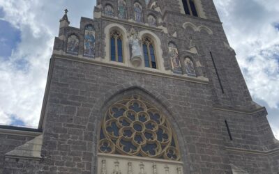
Old & New Hötting Parish Church / Plague Cemetery
Schulgasse / Schneeburggasse
Hungerburg
High Innsbruck
Villa Blanka & Voliere
Weiherburggasse 31
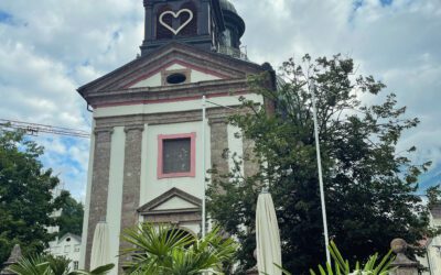
Pfarre Mariahilf
Dr.-Sigismund-Epp-Weg
Theresienkirche
Gramartstraße 4
Weiherburg & Alpine Zoo
Weiherburggasse 37-39
Turnusvereinshaus & Waltherpark
Innstraße 2
Büchsenhausen Castle
Weiherburggasse 3-13
St Nicholas Church & Cemetery
Schmelzergasse 1

Gasthaus Elephant & Gasthof zur Eiche
Innstraße 85 / 87
Workers' housing & Weyrer area
Ferdinand-Weyrer-Straße
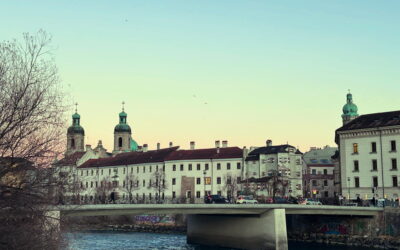
Inn bridge
Innstraße 5 / Innrain 1
Mariahilfzeile & Marketplace
Mariahilfstraße / Marketplace